The group has made research progress in the direction of dynamic flood population exposure simulation in urban agglomerations:
Flooding is a major natural disaster affecting human society, and accurate exposure assessment is crucial for flood risk management. Traditional flood exposure assessments often rely on the overlay analysis of static population distributions and natural flood simulation data, which fail to fully consider the impact of inter-city population mobility patterns within urban agglomerations, as well as the role of reservoir operation during simulated flood processes. To address this issue, Ph.D. candidate Xiaoyuan Xiao published research titled "Modeling Dynamic Flood Population Exposure in Coupled Human-Water Systems: The Role of Reservoir Regulation and Population Migration" in Water Resources Research in October 2025.
This study constructs a dynamic flood exposure simulation framework for urban agglomerations that couples reservoir operation with inter-city population mobility, enabling dynamic flood exposure assessment within a coupled human-water system. The Pearl River Delta (PRD) urban agglomeration was selected as the study area to conduct the research on dynamic flood exposure.
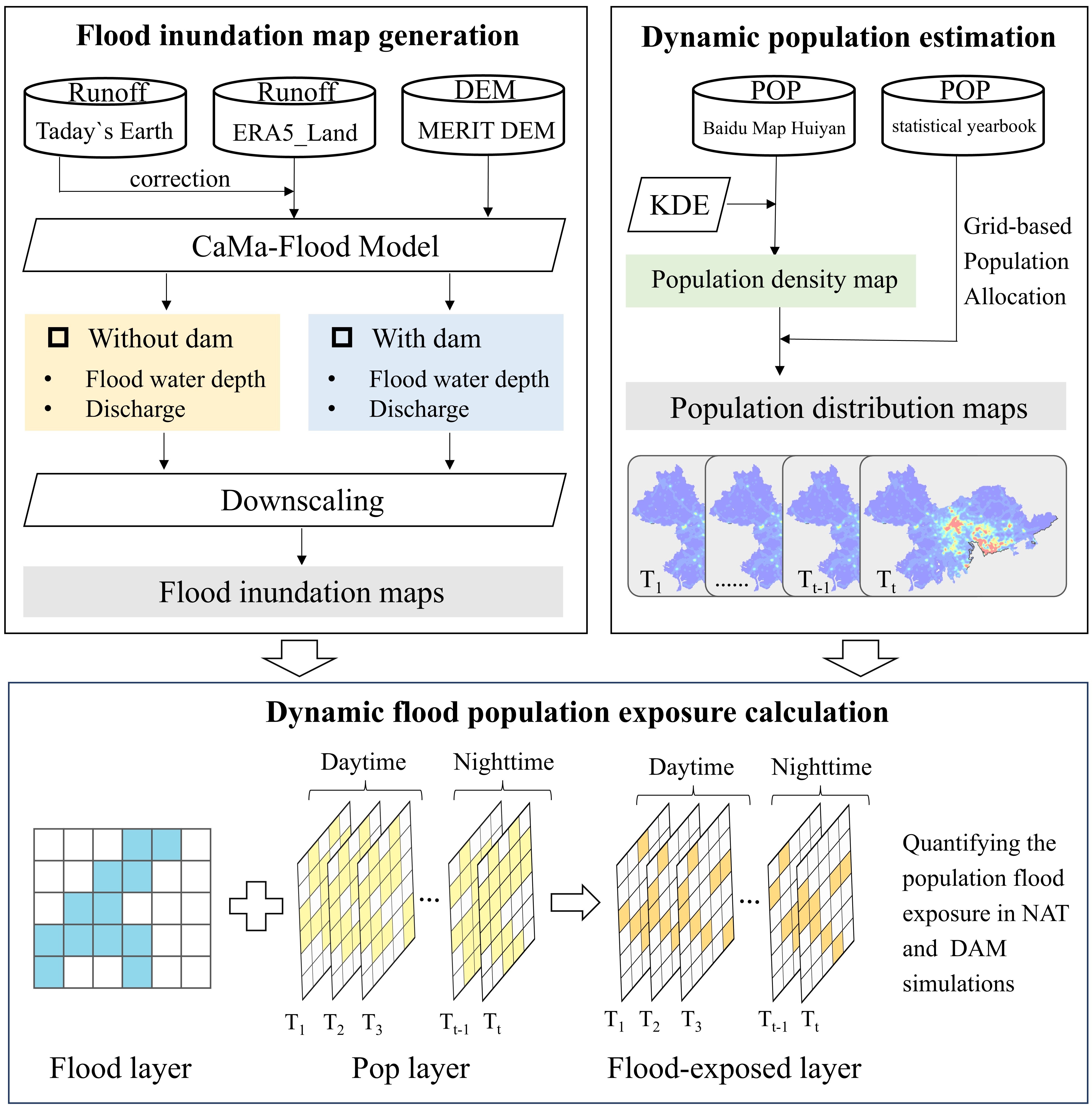
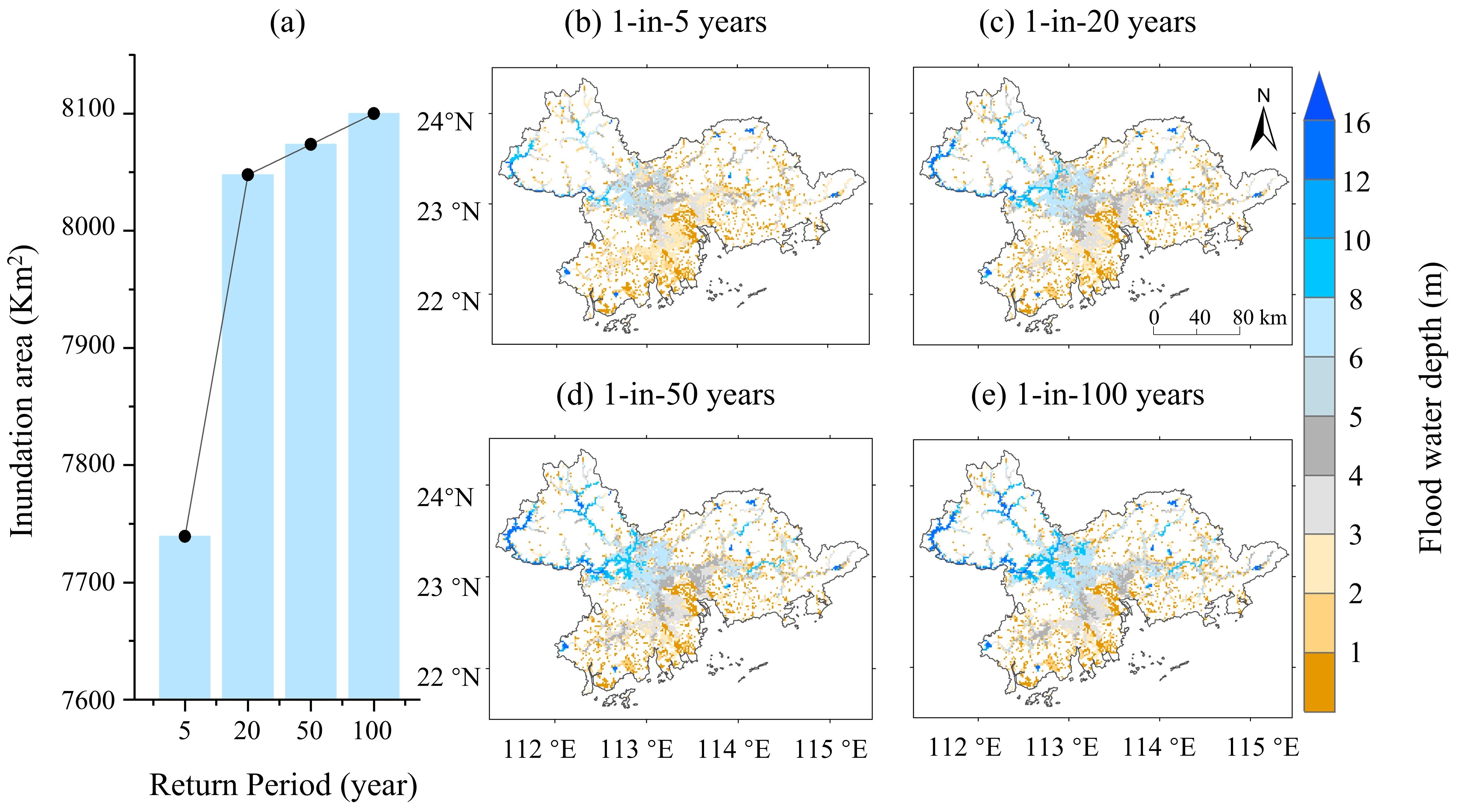
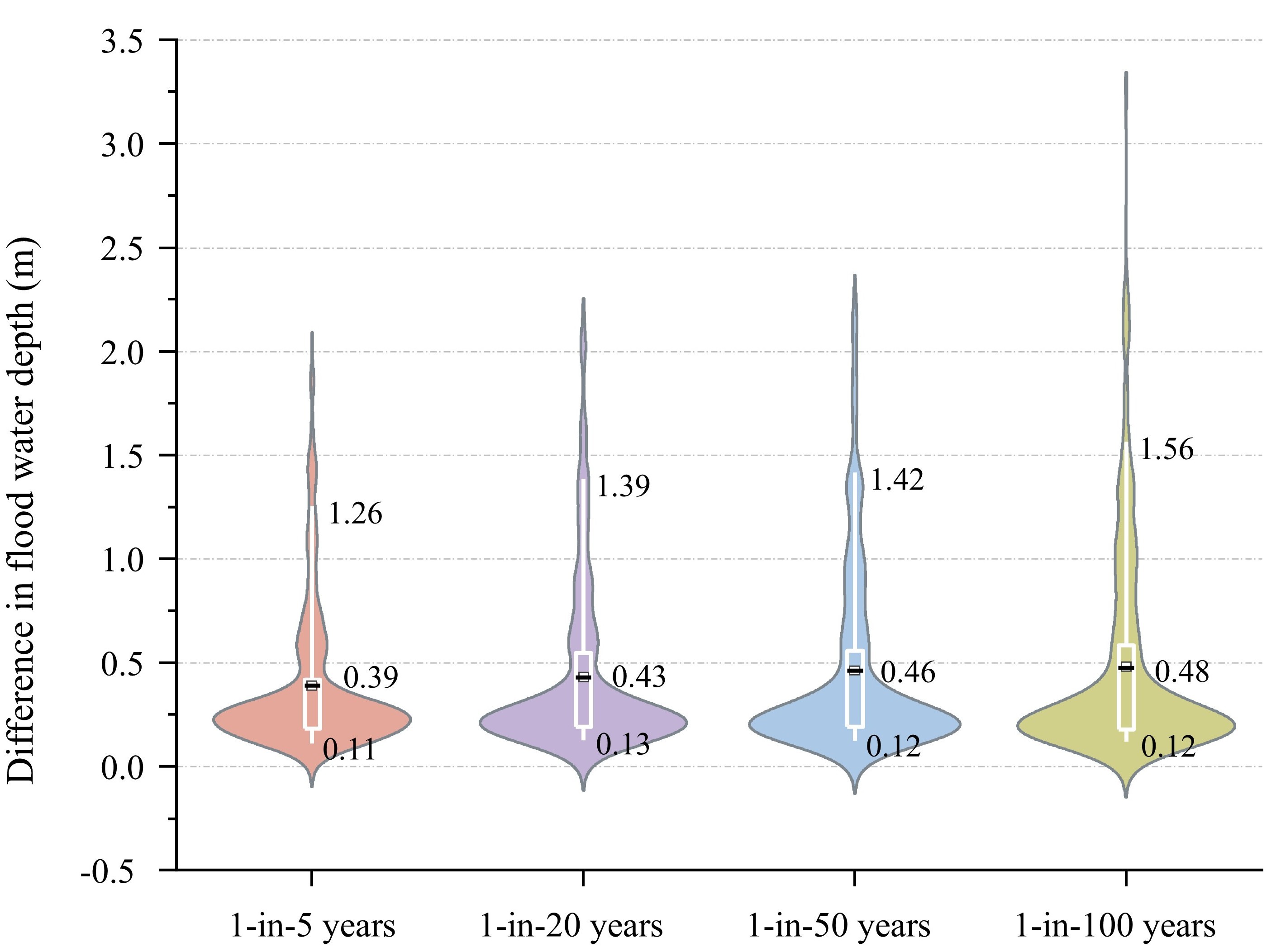
The study utilized the CaMa-flood model to simulate flood disaster data under scenarios with and without reservoir effects for the period 1989–2023. The Gumbel distribution was employed to fit flood inundation data for multiple return periods (5, 20, 50, and 100-year events). The results indicate that reservoirs play a significant role in flood regulation. Under 5–100 year flood scenarios, incorporating reservoir operations reduced the flood hazard level faced by the exposed population by 8–11.8%. Compared to simulations without reservoirs, simulations with reservoirs reduced the average water depth by 0.39 m, 0.43 m, 0.46 m, and 0.48 m for the 5-year, 20-year, 50-year, and 100-year return periods, respectively. The magnitude of reduction increases with the return period (with the largest reduction observed for the 100-year event).
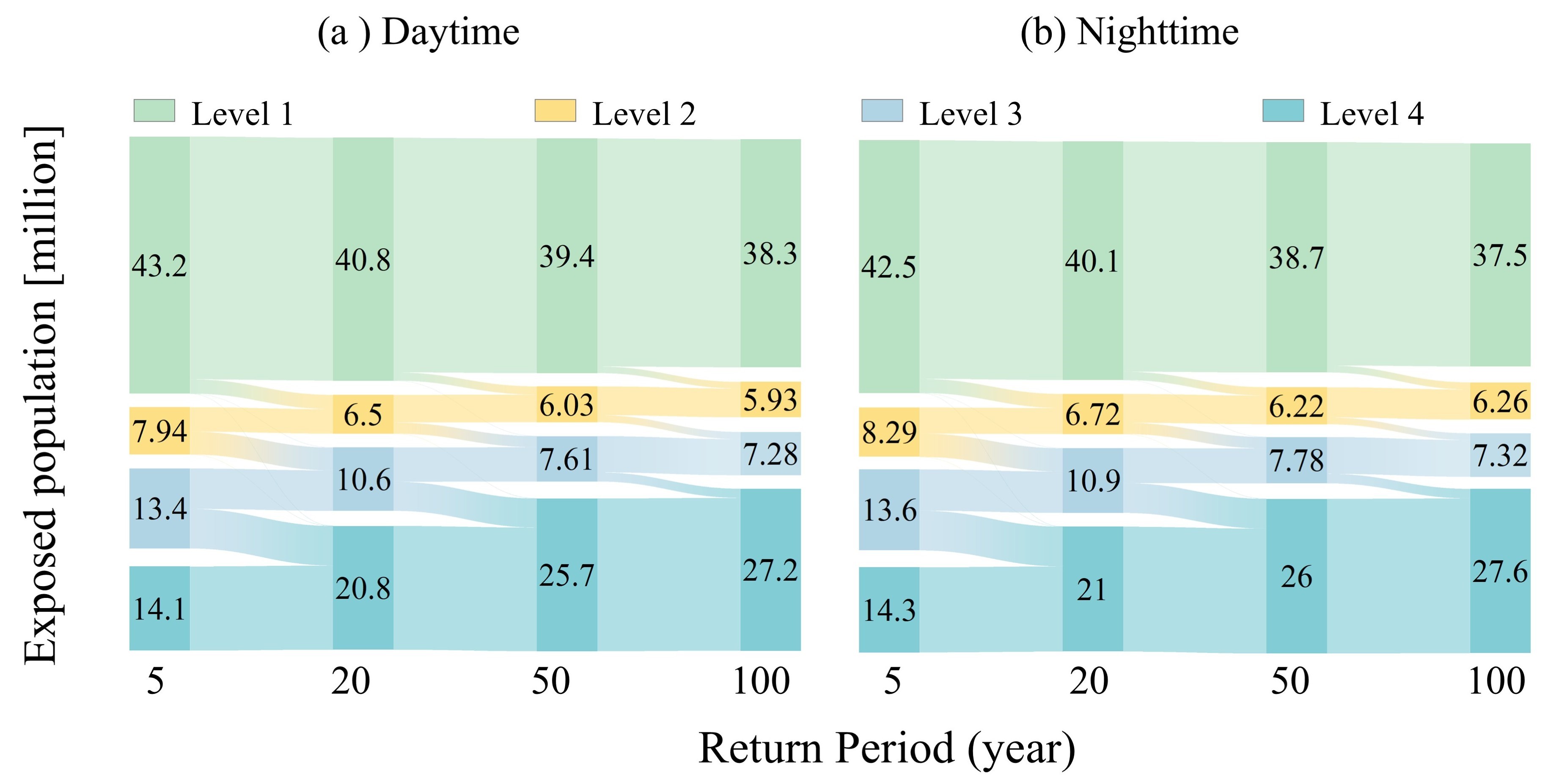
Based on mobile phone location data provided by the Baidu Huiyan platform, the study extracted the day-night population distribution of the PRD urban agglomeration (Figure 5). Significant differences in population distribution were found across the PRD. To explore changes in flood-exposed populations across different time periods and flood return periods, the study analyzed the transfer and variation of exposed populations under different flood risk levels in the reservoir scenario. As shown in Figure 5, with the increase in return period, the population exposed to Level 2–3 risks gradually decreased, while the population exposed to Level 4 risk increased. This is because areas classified as Level 2–3 risk zones are shifting to Level 4 risk zones. Under the 100-year return period scenario, the population exposed to Level 4 risk accounted for 67.2% of the total exposed population, reflecting the severe impact of such extreme flood events. Furthermore, across all return periods and risk levels, the nighttime exposed population was consistently higher than the daytime level. During 5–100 year floods, the nighttime flood-exposed population was 681,000 to 777,000 higher than during the daytime. This indicates that the population faces higher flood risks at night. If the PRD urban agglomeration encounters flooding at night, the consequences will be more severe, necessitating the refinement of prevention and response measures specifically for nighttime flood scenarios.
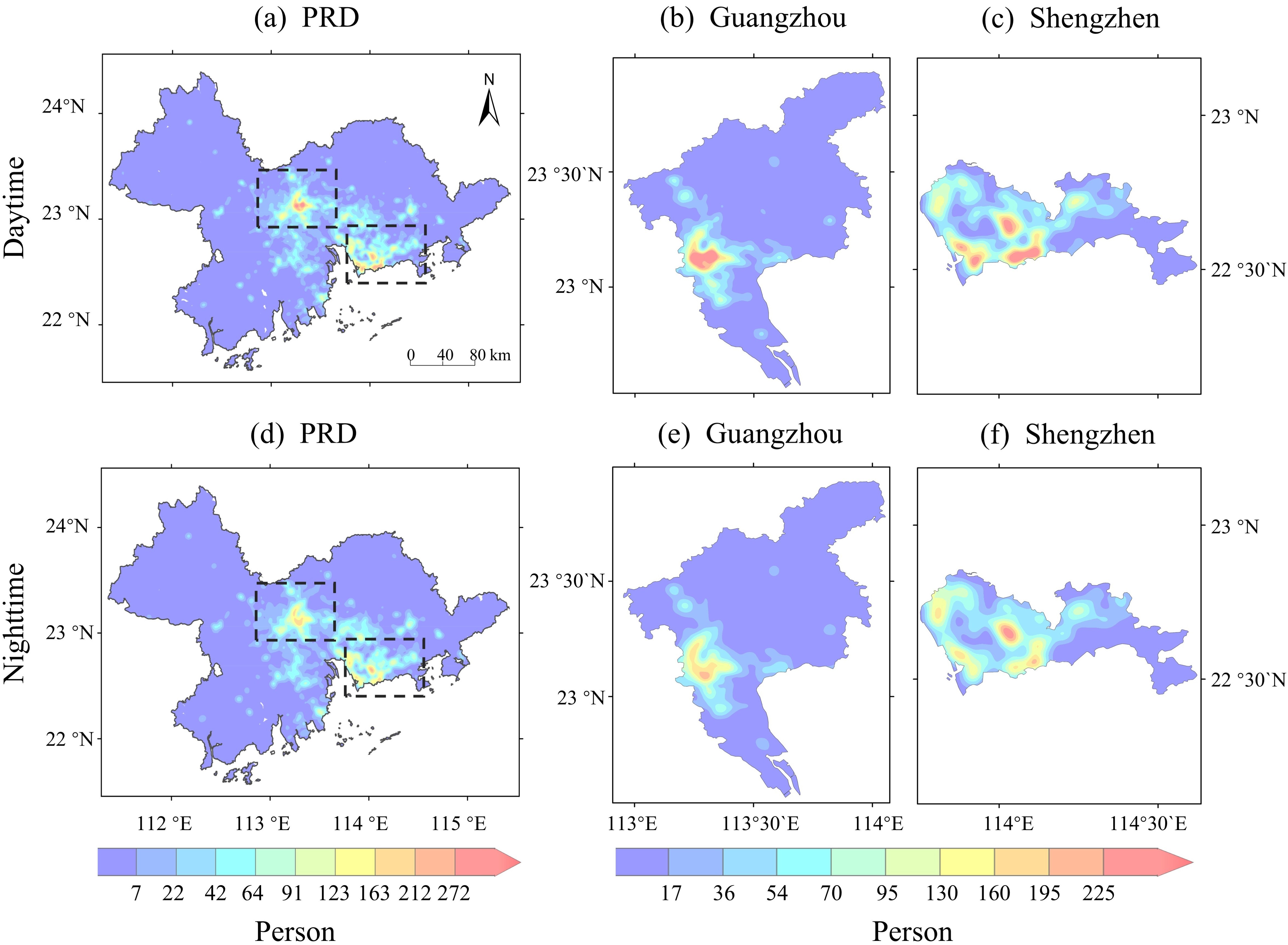
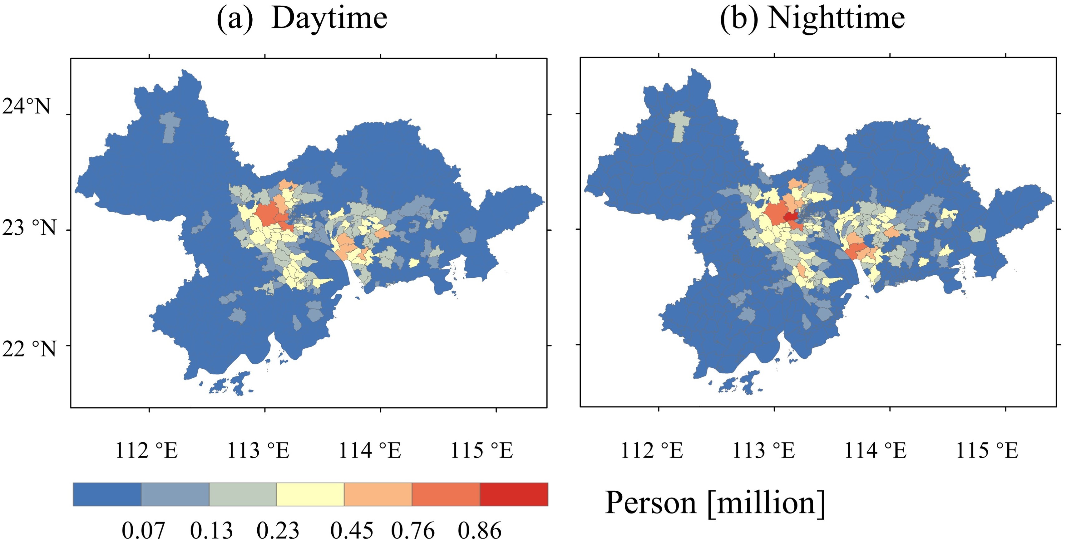
To reveal the spatial differences in day-night population exposure, the study selected the 100-year return period as a typical flood scenario to simulate township-scale exposed populations during day and night (Figure 7). The results show that townships with high population exposure risks are mainly distributed in cities such as Guangzhou, Shenzhen, Dongguan, Foshan, and Zhongshan. In these high-risk areas, the nighttime exposed population is typically larger than the daytime population. This difference directly stems from commuting patterns within the urban agglomeration. Combined with the analysis in Figure 2, during the daytime, parts of the two major population centers (Guangzhou and Shenzhen) are located outside flood risk zones. However, when the population returns to surrounding residential areas at night, large numbers of people migrate into flood risk zones. This day-night migration pattern results in a higher exposed population during nighttime floods compared to daytime.
Overall, this work innovatively constructs a dynamic flood exposure model for urban agglomerations that couples reservoir operation with inter-city population mobility. It reveals the characteristics of dynamic flood exposure risks and enriches current research on flood exposure in urban agglomerations, providing a reference for dynamic flood exposure studies in megacities and urban agglomerations. In future research, the team will explore the dynamic response of flood exposure to other adaptation measures (such as dikes and pumping stations). Additionally, the impacts of climate change and urban expansion on population mobility will be incorporated to further improve dynamic exposure assessment and risk management.
First author: Yuanyuan Xiao
Corresponding author: Prof. Qiang Dai
Other authors: Rui Liu, Duanyang Ji, Assoc. Prof. Xiaoying Lai, et al.
Link to the paper: https://agupubs.onlinelibrary.wiley.com/doi/10.1029/2025WR041234