Our group has made research progress in dynamic flood population exposure simulation for urban agglomerations:
Floods are among the most frequent and destructive natural hazards worldwide, posing serious threats to lives, property, and infrastructure in both urban and rural settings. Accurately assessing population exposure to flood risk is a cornerstone of effective disaster preparedness and urban flood resilience. However, conventional assessment approaches rely predominantly on static population data, failing to capture the spatiotemporal dynamics driven by commuting and daily mobility. At the same time, urban morphology — encompassing spatial layout, built environment characteristics, and socioeconomic attributes — profoundly shapes flood propagation and the distribution of population risk. These two limitations together lead to significant biases in flood risk assessment outcomes. To address these challenges, student Rui Liu and collaborators published a research article titled "Designing Flood-Resilient Cities: How Urban Morphology Shapes Population Exposure Risk" in Risk Analysis in March 2026.
The study focuses on 26 prefecture-level cities in the Yangtze River Delta Urban Agglomeration (YRDUA) as the analytical units. By integrating the CaMa-Flood hydrodynamic model with hourly population distribution data derived from Baidu heatmaps, the study constructs a dynamic flood population exposure assessment framework. Random forest modeling, SHAP analysis, and Spearman rank correlation are then applied to systematically quantify the driving mechanisms through which urban morphology shapes spatiotemporal variability in flood exposure risk.
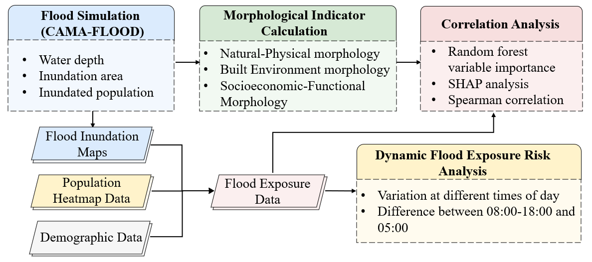
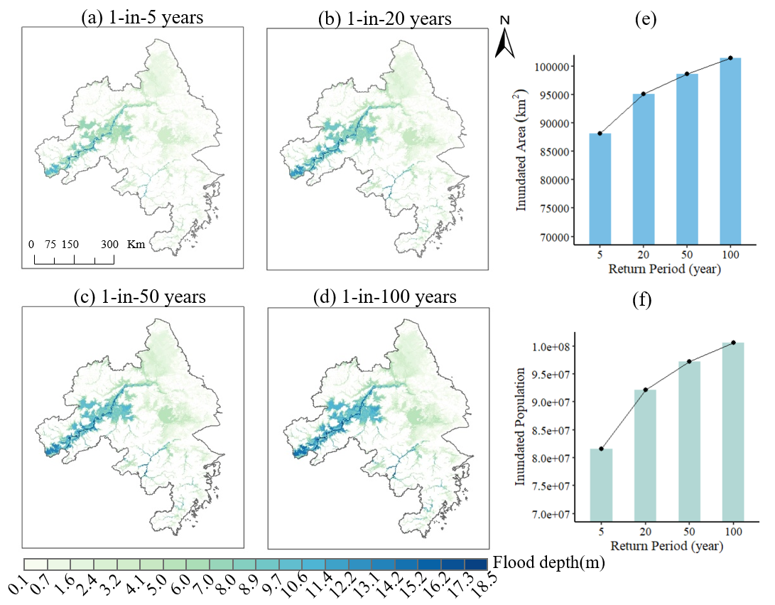
Flood inundation across the YRDUA was simulated under four return period scenarios (5-, 20-, 50-, and 100-year events) using the CaMa-Flood model. Results reveal a nonlinear amplification pattern: from the 5-year to the 100-year flood, the inundated area increases by only 15.1%, yet average flood depth rises by 54% and the exposed population grows by 23.2%. This "limited spatial expansion but sharp increase in depth and exposure" pattern highlights the structural vulnerability of high-density urban areas — even a modest expansion of flood extent can rapidly engulf large populations concentrated in urban cores, causing a disproportionate surge in risk.
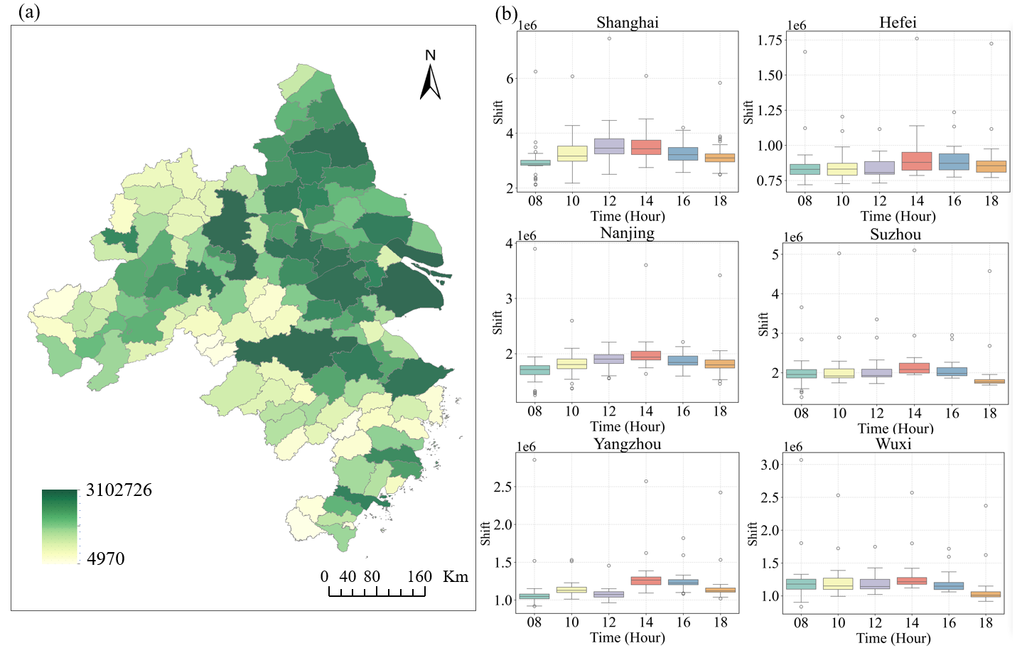
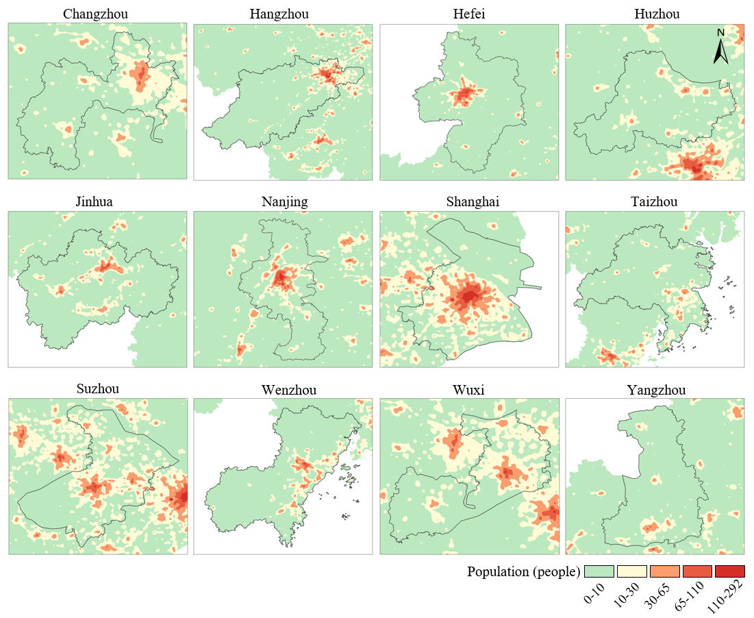
Using hourly Baidu heatmap data from June to August 2024, the study further reveals pronounced diurnal variability in flood population exposure. Taking the 05:00 population distribution as the baseline, intraday exposure amplitudes during the morning commute peak (08:00–14:00) reach up to 77.0%. In major metropolitan cores such as Shanghai and Nanjing, the exposed population shifts by 2.3 to 6.1 million between morning and afternoon peaks, driven primarily by the intense daytime concentration of people in central business districts.
Marked differences are observed across urban forms. Cities with strong monocentric dominance (e.g., Shanghai, Nanjing) exhibit far greater exposure fluctuations than those with balanced polycentric structures (e.g., Suzhou, Wuxi, Wenzhou). Specifically, the mean Normalized Exposure Shift (NES) index for monocentric cities is 0.0658 — 128.0% and 128.8% higher than weak monocentric and polycentric cities, respectively. On average, monocentric structures yield 91.8% higher exposure than polycentric configurations, and the gap between the maximum and minimum NES across all sample cities reaches 351.7%, underscoring the profound differentiation in exposure risk associated with different urban forms.
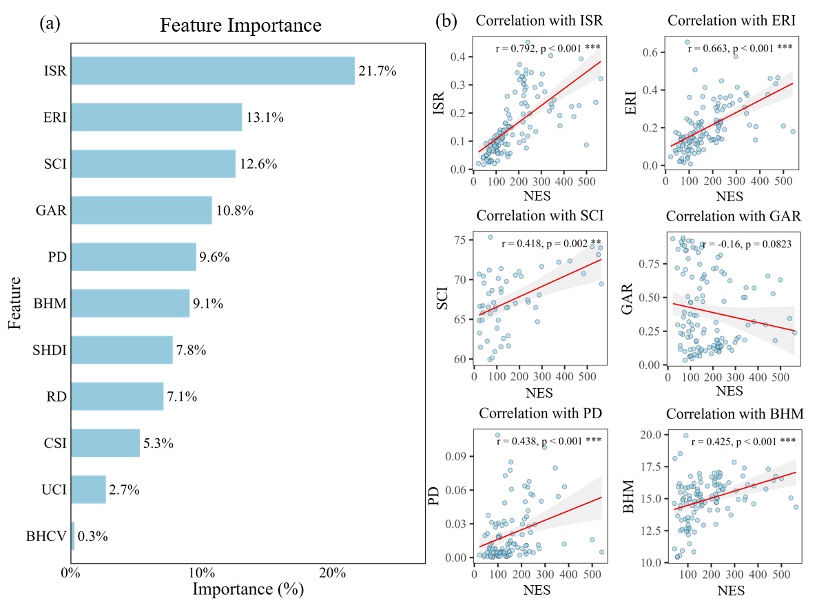
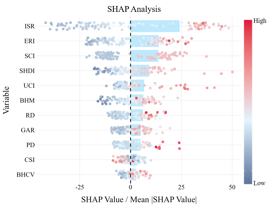
To further quantify the influence of urban morphology on flood exposure dynamics, a comprehensive indicator system encompassing 11 metrics across three dimensions — natural-physical, built environment, and socioeconomic-functional — was constructed, and a random forest (RF) model was employed to assess their relative contributions. Variable importance rankings identify impervious surface ratio (ISR, 21.7%), economic radiation intensity (ERI, 13.1%), and spatial clustering index (SCI, 12.6%) as the top three predictors, collectively accounting for nearly half of the model's explanatory power. Spearman correlation analysis confirms significant positive associations between these variables and NES: ISR (ρ = 0.792, p < 0.001), ERI (ρ = 0.663, p < 0.001), and SCI (ρ = 0.418, p = 0.002). Natural-physical indicators (river network density and channel sinuosity index) make comparatively modest contributions, each below 8%. SHAP analysis reveals consistent directional patterns: high values of most indicators positively amplify exposure shifts, with greater urbanization intensity, spatial centralization, and functional density all intensifying temporal exposure volatility. The channel sinuosity index, by contrast, exhibits an inverse effect — greater channel meandering attenuates flood peaks and dampens exposure dynamics.
The findings carry important practical implications for urban planning and flood risk governance, offering multi-dimensional strategies for building flood-resilient cities. In terms of spatial planning, the study advocates promoting polycentric urban development — through establishing secondary urban centers and improving job-housing balance — to decentralize economic activity and population flows, thereby structurally reducing exposure concentration in urban cores. On the engineering side, the study recommends expanding green-gray infrastructure hybrid approaches (e.g., Sponge City principles, rain gardens, permeable pavements) in highly impervious urban cores, while preserving multifunctional flexible open spaces as temporary water retention zones. For dynamic risk management, the study emphasizes the need for time-sensitive exposure monitoring systems that issue targeted warnings during daytime commute peaks, optimize drainage operations through model predictive control, and reinforce critical transport infrastructure to prevent commuter disruption during flood events. For cities with pronounced nighttime exposure risk — such as those with 24-hour industrial or medical operations — priority should be given to deploying real-time sensor networks and developing dedicated emergency protocols for night-shift workers and vulnerable populations.
First Author: Rui Liu
Corresponding Authors: Associate Prof. Xiaoying Lai
Co-authors:Prof. Qiang Dai, Yuanyuan Xiao, Associate Prof. Jun Zhang, Prof. Huimin Wang